Running out mid/end 2017!
Service for this equipment continues!
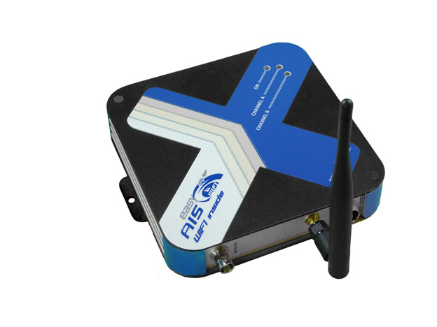
Weatherdock WiFi products are a quantum jump regarding the simplification of data use aboard. With the built-in WiFi module, an additional navigation place is created on your boat. Received AIS data are wirelessly linked to your mobile device. The latter can be a smartphone, tablet PC , iPhone or iPad.
To visualize data on your mobile device, Weatherdock offers a free App named “easyAIS”, which is available for download through the Apple store.
In case you are running a mobile device with lower screen resolution, we still recommend to use a suitable plotter with appropriate resolution for your safety.
Function:
The easyAIS-WiFi receives the incoming AIS data sent by commercial vessels (Class A) and pleasure boats (Class B). These telegrams are processed into a NMEA protocol which can be interpreted by chart plotters or PC software. With the wireless link to your mobile device, these data will be promptly received there as well.
Running the “easyAIS” app, you will see a radar screen appearing, showing allreceived AIS targets within range. A click on a target will prompt you detailed information to this specific target, such as ship’s name, speed and course over ground, etc. Additional information to your own boat’s navigational status like your own speed, course, wind, etc. are available through sub-menues of the App, if you feed the easyAIS-WiFi built-in multiplexer with boat information.
- fully compatible with popular AIS navigational Apps for iPad®, iPhone® or iPod®, e.g.
- – iNavX (charged) A new license for mobile device is mandatory.
- – AIS Radar (charged)
- – iPilot (charged)
- fully compatible to charged Android-App iRegatta
- fully compatible to Windows XP, Vista or Windows 7 (system running 32 bit)
What is necessary to use the easyAIS_Wifi?
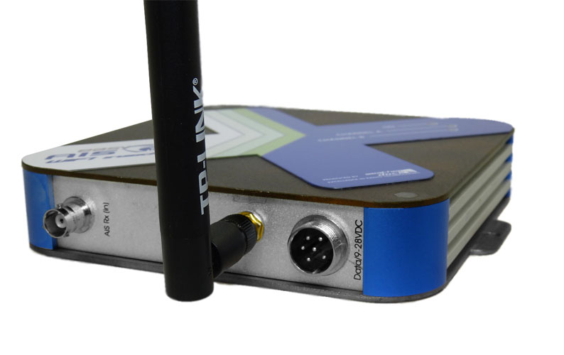
Required is an AIS compatible chart plotter or PC software and an own VHF antenna. As an alternative you can use a VHF/AIS antenna splitter like the easySPLIT to use the already existing VHF antenna for both, the VHF radio communication and the AIS reception.
The mobile device has to have AIS compatible software or App too.
- integrated Wifi module
- provides wireless TCP/IP, NMEA 0183 (34800 baud)
- NMEA input with multiplexer function for GPS and other boat instrument data
- WiFi range of 30 m without any special antennas (depending on local conditions)
- fully compatible with popular navigational software or Apps for iPhone or iPad
AIS receiver
- dual chanel receiver on 161,975 MHz and 162,025 MHz
- 25 kHz chanel spacing
- -112 dBm RX sensitivity
Requirements for the DC supply
- 9 V – 28 VDC
- 250 mA
NMEA input
- multiplexes NMEA data at a data rate of 4800 baud with internal AIS data
NMEA output
- NMEA 0183 (34800 baud)
- NMEA message type: VDM
WiFi
- maximum range: 100 m (in free air)
- usual range: approx. 30 m without the use of any special antenna
- maximum number of WiFi users: 1
Antennas
- connection to existing VHF antenna required
- Wifi antenna supplied
integrated WiFi module
provides wireless TCP/IP, NMEA 0183 (34800 baud)
NMEA input with multiplexer function for GPS and other boat intrument data
WiFi range of 30 m without any special antennas (depending on local conditions)
fully compatible with popular AIS navigational Apps for iPad®, iPhone® or iPod®, e.g.
- iNavX (charged) A new license for mobile device is mandatory.
- AIS Radar (charged)
- iPilot (charged)
fully compatible to charged Android-App iRegatta
fully compatible to Windows XP, Vista or Windows 7 (system running 32 bit)