Situational Awareness for your coast
Maritime Assets are soft Targets Terrorists & pirates are more and more targeting locations or facilities considered too ‘soft’. As was evident in such attacks as the USS Cole, M/ V. Limburg & the tragic attacks of 26/11 in Mumbai. It is clear that “soft” targets have included attacks on Merchant & Naval ships, Coastal Tourist hotspots & hotels, Bridges, commercial shipping, oil & Transport critical infrastructure. Perils of pirate attacks is increasing by the day. All these attacks have been carried out using small crafts & fi shing vessels. Since these attacks, the importance of small craft/fishing vessel tracking has taken great importance & have highlighted the need for security on coastal borders. Terrorism today, is a worldwide Issue.
Who is front of your coast?
Security is a key word today and being ”on-line” with all borders and water front is essential for the new world order. The tracking of small crafts have for several years already, been an aim of authorities worldwide. No cost e effective fool proof solution has been found yet. A vessel or craft close to the coast is the immediate threat. Various technologies have been tried and apart from satellite tracking no other technology has succeeded. But then Satellite tracking is very expensive & position updates are inadequate for security. So is GSM which apart from being pricey is susceptible to network congestion and breakdowns. Inadequate reporting rates make tracking useless for security.
Why Class B is Not the Solution?
The most obvious step in tightening security is to have knowledge of the movements of all vessels along the coastline. Thus incorporating any tracking projects into the security agenda is important. For the IMO class vessels this is achieved with a Class A AIS. What about small boats, yachts, harbor crafts, towed barges, jet ski….. in general small crafts? Class B with CSTDMA is not suitable for various reasons. Most important being that high quality of class B targets will overload existing coast AIS networks. It should be kept in mind that all ships in vicinity would also see 1000’s of targets. With this magnitude of clutter it could become “hazard to navigation”. USCG cautions class B users are not seen by all.
vmsTRACK or vmsTRACK-PRO for MDA
vmsTRACK from Weatherdock is the world’s 1st purpose built tracking solution for fishing vessels & other small crafts with or without power. This is a result of over 15man-years that have been spent on listening to fishermen needs as well as homeland security requirements. The end result is a product that is robust, designed by experienced engineers and made in Germany. vmsTRACK helps bring small boats, leisure crafts & fishing vessels into a national Maritime Domain Awareness network.
vmsTRACK is an award winning TDMA based VHF radio unit that can work on programmable marine band frequency. Due to the nature of TDMA technology it allows several users to share the same frequency channel by dividing the signal into different timeslots. vmsTRACK has a unique capability of transmitting a SOLAS “Panic” alert as AIS MSG 14 which can also be received by any one carrying a Class A or B receiver or transponder.
vmsTRACK and vmsTRACk-PRO are
- Suitable for leisure boats, ski jets, harbor crafts etc
- A Coastal security & MDA application device
- Ideal for coastal fishing fleet tracking & Management
- A “Friend or Foe” (Pirate) identifying device”
- Useful to monitor movement of vehicles in a port
- An aid to Pilots and boarding parties
- A Radar less traffic monitoring system for small ports
- MDA software available for vmsTRACK
Key Features of vmsTRACK
- TDMA technology tested & Proved
- Smallest self contained device in the world
- Future proofed and tested for AIS satellite pickup
- Unique ID programmable for each unit
- Will work with existing AIS shore infrastructure
- Embedded geo reference coast line table
- Incremental tracking as it nears coast
- Buitl-in Emergency Distress button uses AIS MSG14
- Distress complies with SOLAS & received by all AIS
- Intelligent high tech tamper proof solution
- Water proof to 10m depth – IP 68
- LED flash for night navigation alert
- Integrated fast high sensitive GPS
- Palm size and easy portability in emergency
- Size 125mm x 68mm x 30mm, Weight 210 gms
- External Antenna option available on request
- Power Output approx 2 w – No Installation required
- Built in rechargeable battery for up to 120 Hrs
- Programmable to any Marine Frequency
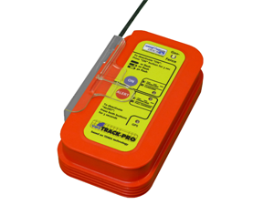
A193 vmsTRACK-PRO-CS
Tracking via VHF. Portable locating device with CSTDMA technology.