
Weatherdock with its own stand at the SMM in Hamburg
In 2016 Weatherdock comes again with the slogan:
“Setting the course to SMM in Hamburg – the leading international maritime exhibition”
Weatherdock will present at the SMM in Hamburg its product portfolio around the topics “Tracking and Locating”.
Especially in today’s time concepts like “Maritime Domain Awareness”, “Coastal Surveillance” or “Offshore Border Control” are more important as ever. Identifying and knowing what happens in front of our territory – and to know what to do as early as possible – have become important issues. With the portable position transmitters vmsTRACK of Weatherdock the authorities and fishing fleets are able to accurately cover these requirements.
When it comes to increase the safety of the crew on board, Weatherdock provides a powerful SOLAS certified AIS SART emergency transmitter, with its easyRESCUE devices. Many companies and international organizations know how important this issue is, and therefore they already trust Weatherdock products.
Countdown to SMM
Day(s)
:
Hour(s)
:
Minute(s)
:
Second(s)

Our partner on the stand: vesseltracker.com
Vesseltracker.com GmbH, founded in 2006, is a leading provider of global AIS vessel movements and maritime information services that was founded by an Information Technology specialist and Port Operations Manager with the goal of bringing higher levels of transparency and clarity into the market.
Well over a quarter of a million users from multiple sectors across the globe access vesseltracker.com services to get up-to-date vessel movements, maritime news and events and in depth information on vessel characteristics, specifications and ownership/management details and an ever growing number of customized data delivery projects, reports and analytics.
Vesseltracker processes billions of messages every day from the largest and fastest growing privately owned AIS receiver network on the planet, and the most technologically advanced and only AIS dedicated satellite constellation. Vesseltracker further applies auto cleanse and auto correct algorithms making it possible for you to accurately track well over 120,000 vessels on any given day, from anywhere in the world. Our services are designed to suite the variety of challenges faced by companies, authorities and individuals who require a complete overview within the maritime sector on both a local and/or global scale.
Some key features Vesseltracker offers:
- Customized real-time and historical data delivery including reports and analytics on vessel movements, port events and customized projects so you can utilize our data for internal applications, analytics and/or reporting systems.
- Comprehensive vessel database of specifications, characteristics, equipment, ownership and management information, with all changes tracked.
- Database of well over 1,000,000 vessel and port images.
- Alerts on vessel status and customizable regions via email, SMS and phone plus multiple vessel lists with email noon-reports to save time and make the system work for you.
- Up-to-date information and alerting systems on expected, arrived and departed vessels for a single port or a list of ports.
- Map views and layers including google satellite, google earth, nautical charts and global and local piracy and weather information.
- Distance and ETA calculation to enable the accurate prediction of when a vessel will arrive.
- Mobile access for tablets, iPhone, iPad, Android, and Blackberry.
Our products for you
Real-Time vessel & object monitoring by VHF
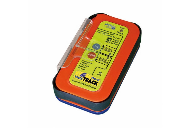 Real-Time vessel & object monitoring by VHF
The system allows persistent locating and monitoring of vessels and moving objects in a special area via VHF technologies. The vmsTRACK-PRO-CS is working with CSTDMA Class B transmission functionality.
CSTDMA is the short cut for “Carrier Sense Time Division Multiple Access” which is used for AIS Class B units. The vmsTRACK-PRO-CS operates on the principle “listen before talk”. If a transmission is due, the transceiver watches the dedicated slot and if there is actually no transmission in the slot from a Class A transceiver, then the CSTDMA unit starts transmission his own in this slot.
Palm-sized for every request
The vmsTRACK-PRO-CS is a small portable “grab’n’go” position transmitter, which broadcasts in a pre-set time interval via VHF radio frequencies. The unit is ideal for coastal fishing fleet, movement monitoring of harbour vessels, small target tracking and pleasure boaters tracking. It is suitable for fishermen, vessels, leisure boats, ski jets, harbour crafts, pilot vessels, etc. The system is expandable to a full target management system. With the usage of the vmsTRACK-PRO-CS real-time-tracking system, a radar-less traffic monitoring system for economic application is possible.
By means of the transmission contained information about current GPS position as well as curse and speed over ground of the object, persistent real-time-tracking and monitoring of special interest objects is possible for a base station. Such a base station only needs a special tuned receiver unit to get these position reports, if customized frequencies are used. Creation of a so called “closed user group” is possible with such a system, in which only the base station has the permission to look into by means of these customized frequencies. The vmsTRACK-PRO-CS is also able to run on regular AIS frequencies which makes a special tuned receiver needless.
“Who and Where” for coastal security and fleet management
The real-time-knowledge of “who and where?” is very important in administration of coastal fishing fleets as well as in coastal boarder security issues. By transmission of special names and unit IDs “friend or foe” identifying is possible.
AIS S.A.R.T. easyRESCUE
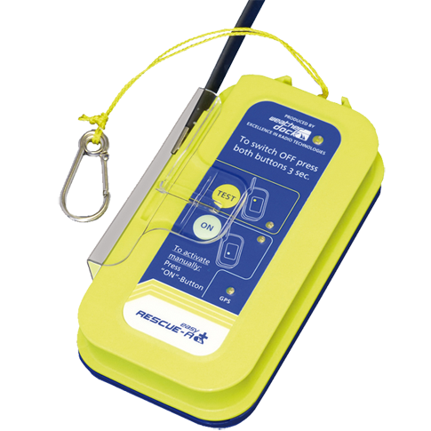 If you can find him, you can’t find him,
you can’t save him!
The easyRESCUE is a fully cedrtified AIS S.A.R.T. emergency transmitter. With a built in GPS receiver, the easyRESCUE as well as the variants easyRESCUE-A or easyRESCUE-BW-LV transmit an emergency AIS-SART sentence which triggers an alarm on all AIS enabled chart plotters / PC’s within range, along with the Lat/Long of the current position including speed and curse over ground of the drift.
The GPS is a new generation fast acquiring type and the VHF AIS transmitter repeats the message and position several times per minute. This enables all vessels within range to assist with the rescue if they have an AIS receiver or transponder. This might be the difference between saving or loosing a life.
![]()


