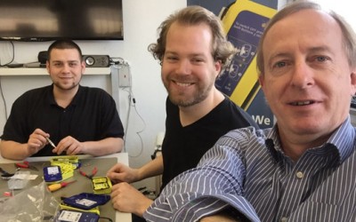
Weatherdock: sponsor of “The Royal Langkawi International Regatta”

The regatta tracking devices  of Weatherdock are now also used in the largest sailing event in Malaysia: “The Royal Langkawi International Regatta”. This event will take place from 12 to 17 January.

In collaboration with our distributor Teraju Tritech we are present there as a co-sponsor of this event.

easyRX2S

easyRX2S

This product range is no longer produced.

All downloads can be found here under “Downloads”.

Unfortunately, repairs for easyRX2 devices are no longer possible.

E

easyRX2S

easyRX2 S

p

Product information

p

Product information

Function

The Class B unit easyRX2S receives AIS ClassA and ClassB according to ClassB standard.

The easyRX2S performs a lot of usefull features:
By means of USB port connection to PC or Laptop is possible. With contained software it can be choosen between 38400 or 4800 Baud data rate. Function activity is shown by 8 LED’s.  The easyRX2S is able to interpret incomming AIS data for CPA alert or AIS S.A.R.T. ermergency messages. Additional the easyRX2S devices can be used as power surce for external alerting devices. All received AIS data can be stored with internal SD Card recorder. With the build-in multiplexer input 3 devices with different baud rate can be pluged to the easyRX2S units. At least the external cable harness gives the possibility for outsourcing functionaly like “change into silent mode ” or “PAN PAN emergency call” by switch.

easyRX2S and gadgets that fit together

Your PC has to work at least on WIN XP SP2 and screen resolution  1024*768 for configuration. Plotter or PC software have to be intermateable to AIS to display incoming AIS data on screen.

Z

Highlights

  • Additional USP port for more connectivity
  • 38400 or 4800 Baud rate selection possible by software
  • 8 operating LEDs for more convenience
  • SD Card recorder for blackbox employment
  • Enlarged voltage input
  • Integrated multiplexer
  • Separate cable harness for “silent mode” or “PAN PAN” persistent signal
  • Plotter independent CPA alert
  • Plotter independent AIS S.A.R.T. alert
P

What is needed?

What is needed to run the easyRX2S?

The ClassB device needs a separate GPS antenna and an own VHF antenna. As an alternative you can run the easyRX2S with the VHF antenna switch easySPLIT-OCB for using your existing VHF antenna. A separate GPS antenne is still needed. An other alternative is the VHF/GPS combi antenna.

Technical Data

  • AIS receiver with integrated GPS receiver
  • 2 receiver
  • Responsivity: -107dBm minimum, typically -112dBm
  • Data rate: 38400 or 4800 Baud, bi-directional
  • NMEA telegram type: VDM
  • Adapter VFH antenna: 50 Ohm, SO2239
  • Adapter GPS antenna: 50 Ohm, BNC
  • Cabin mounting, IP60, -25°C – 55°C
  • Dimensions: 198mm (L) 158mm (W) 47mm (H)
  • Weight: approx. 275 grams
  • LAN-Module (optional)

Advantages over competitors

  • Plotter independent AIS S.A.R.T. alert
  • Plotter independent CPA alert
  • USB port
  • SD Card recorder

vmsTRACK in action

We receive interesting information from our colleague Jurgens Schoeman from South Africa. We want to share this with you. Jurgens write:

“Over the last two months it has happened twice that our vmsTRACK base station at Hondeklip Bay receives alert messages transmitted by locators in Port Nolloth, a distance of 133km (72nm). The transmitter is mostly at sea level and the receiving antenna about 20m above the water. The base station in Hondeklip Bay sends Petrus and me an SMS with the GPS position when it receives an alert.”

That situation shows how effective a vmsTRACK can work. The distance is considerable, 133 km or 72 nautical miles! Wow!

All about vmsTRACK here …

B024 VHF – Antenna

B024 VHF-Antenna Produktbild
p

Product information

VHF antenna with cable for attachment to the railing to receive AIS signals.

Technical Data

  • Antenna height: 1m
  • Cable length: 20m
  • Frequency range: 162 MHz

Product Pictures

New partner of Weatherdock in Turkey

The exhibition SMM in Hamburg offers not only the opportunity to present the new developments of our product line, it is also a good opportunity to make new partners.

On the second day of SMM 2014, Mr. Kotouczek-Zeise, CEO of Weatherdock, signed a partnership agreement with Mr. Nadir Gürel, manager of the Turkish company Texpert Teknoloji LTD. STI.

We are pleased to expand the list of our partners in Europe with this new deal.

If you are looking for our products in Turkey, please contact our new partner:

TEXPERT TEKNOLOJI LTD. STI.
Cumhuriyet Mah.
1997 Sok. No:5 A/02
34515 ISTANBUL / TURKEY
Tel.:+90 (212) 546 5252
You will find personally and professionally advisory service about the entire Weatherdock product line by Mr Nadir Gürel and his team.

easyRESCUE-DIVEpro on the Maldives

The easyRESCUE-DIVEpro of Weatherdock received at the beginning of 2014 the official approval to be used on the Maldives. That was already good news for our company. But the satisfaction of that achievement did not stop there. Recently one of the most important tourist centers of the islands, the “Ocean Sports Maldives” adopted easyRESCUE PRO as an instrument to strengthen security in offering their services.

Why does a company like “Ocean Sports Maldives” choose easyRESCUE-DIVEpro as an additional safety factor for its customers? The device is an emergency transmitter for diving groups with 2-stage communication: “Closed user position report” and AIS SART Alarm. The unit is developed out of the AIS S.A.R.T. emergency beacon easyRESCUE-DIVE for safari boats as well as diving bases. The unit of each member of the diving group will be activated before diving and handed out with specific briefing “how to use”. A persistent position report will be sent by every unit and received by the diving boat or diving center. By means of position report the diving group could be tracked on water surface to be “insight”. In case of emergency, an AIS S.A.R.T. Alert can be triggered, that can be seen by all ships and (coast-guard) receiving stations in vicinity.

There is no doubt that customers of Ocean Sports Maldives may feel more secure and therefore they can enjoy better their stay on the Maldives. Security means comfort. Providing security is a source of pride and satisfaction for the whole Weatherdock team.

A179 easyTRX – SOLAS AIS Class A

AIS Class A | Inland Transponder in cooperation with CNS Systems™
  • Increased situational awareness for inland navigation, the system communicates the blue sign for inland waters.
  • The AIS transponder can be configured to operate either as an AIS Inland or a Class A transponder.
  • The system communicates required static, voyage related and dynamic data.
The easyTRX – SOLAS AIS Class A/Inland transponder provides SOLAS compliance and BSH certification at very attractive prices. The easyTRX – SOLAS AIS Inland transponder is based on the well proven AIS Class A transponder of CNS Systems and developed in accordance with the latest AIS Inland standard requirements.
The AIS Inland transponder is type approved by Fachstelle der WSV für Verkehrstechniken FVT.
The data link communication covers standard AIS messages and the required static, voyage-related and dynamic data as well as blue sign messages for inland navigation for increased situational awareness and improved safety for the individual ship.
The SOTDMA technology used in the AIS transponder transmits and receives information on all vessels within VHF coverage. This information includes position, identity, course over ground, heading, and rate of turn as well as navigational status and the destination of the ship.
The AIS Inland transponder broadcasts Inland blue sign status messages for upstream or downstream navigation; ships passing on starboard side, hazardous cargo carriage (Blue Cones), and estimated time of arrival at locks, bridges and terminals. Lock management, information on draught, type of cargo and destination is vital for decision making and safe maneuvering along the inland waterways.
The information received from, and provided to, the ships is easily plotted on any ARPA radar or electronic chart system. Maximum situational awareness is accomplished.
Configuration and interfaces
The AIS Class A/Inland transponder is easy to install onboard any ship by connecting it to a GPS and VHF antenna, and is complete after connecting it to the onboard sensors. To maximize the benefi t of the investment, the AIS Inland transponder is delivered with an interface to the Inland ECDIS and/or ARPA radar.
The AIS Class A/Inland transponder consists of an integrated Minimum Keyboard and Display (MKD).
Power
Input voltage 11-36 V DC
Radio
Transmitter output power (adjustable) 1 and 12.5 W, 50 Ohm load
Bandwidth 25 kHz
Protocol TDMA (AIS)
Baud rate 9600 bps (AIS) / 1200 bps (DSC)
Modulation GMSK (AIS) / FSK (DSC)
Frequencies 156.025 MHz – 162.025 MHz
Default channels 87B (161.975 MHz), 88B (162.025 MHz), 70 (156.525 MHz)
Number of receivers 3 (2 AIS TDMA, 1 DSC)
Receiver sensitivity, 20% MER < – 107 dBm


GNSS Receiver
GNSS receiver GPS L1, 50 parallel channels
DGNSS support Yes


Environmental
IEC 60945 Protected installation
Interfaces
VHF antenna N female, 50 Ohm
GPS antenna TNC female, 50 Ohm
Power 3-way plugable screw terminal
Sensor Interfaces 1 to 3 (RS422) IEC 61162-1 or -2
Pilot/Auxiliary (RS422) IEC 61162-2
External Display (RS422) IEC 61162-2
Long-Range (RS422) IEC 61162-2
Blue sign interface Discrete Input 24 V DC / Open
DGNSS correction input (RS232) RTCM/SC-104
Alarm relay Normally closed

Standards
ITU-R M.1371-4
IEC 61993-2
IEC 61162-1, 2
IMO Resolution A.694 (17)
IMO Resolution MSC.74 (69) Annex 3,
TU-R M.825-3
ITU-R M.1084-3,
EC 61108-1,
EC 62288
IPC-A-610 (manufacturing)
RTCA/DO-178B (SW development)
CCNR Vessel Tracking and Tracing Standard for Inland Navigation version 1.01

Physical characteristics
GNSS receiver GPS L1, 50 parallel channels
DGNSS support Yes

Integrated MKD on the front panel
Plugable screw terminals for cable connections

Accessories included

Compliance
BSH Statement of Conformity
FVT type approved


easyPOSALERT, easyPOS’N’HOOK, vmsTRACK – Software

  • Programming-Tool, Version 3.76
  • Product: easyPOSALERT, easyPOS’N’HOOK and vmsTRACK-/PRO
  • Stand: 04.06.2025
  • Size: 35.785KB
  • Type: EXE
  • New:
    • UI
    • New Maps
  • Please repport errors with screenshots to: support@weatherdock.de
  • Programming-Tool, Version 3.74
  • Product: easyPOSALERT, easyPOS’N’HOOK and vmsTRACK-/PRO
  • Stand: 30.10.2023
  • Size: 33.787KB
  • Type: ZIP
  • New:
    • Admin-Light, further settings
  • Programming-Tool, Version 3.73
  • Product: easyPOSALERT, easyPOS’N’HOOK and vmsTRACK-/PRO
  • Stand: 18.04.2023
  • Size: 32.435KB
  • Type: ZIP
  • New:
    • Liberia Map
  • Programming-Tool, Version 3.72
  • Product: easyPOSALERT, easyPOS’N’HOOK and vmsTRACK-/PRO
  • Stand: 08.12.2020
  • Size: 32.290KB
  • Type: ZIP
  • New:
    • Qatar map differed to others
  • Programming-Tool, Version 3.71
  • Product: easyPOSALERT and vmsTRACK-/PRO
  • Stand: 21.04.2020
  • Size: 112.843KB
  • Type: ZIP
  • New:
    • Save Settings by User-INI File
    • Bug-Fix: Bracket- Usage
  • Programming-Tool, Version 3.68
  • Product: easyPOSALERT and vmsTRACK
  • Stand: 05.11.2019
  • Size: 32.260KB
  • Type: ZIP
  • New: added Qatar Map
  • Programming-Tool, Version 3.67
  • Product: easyPOSALERT and vmsTRACK
  • Stand: 15.10.2019
  • Size: 32.884KB
  • Type: ZIP
  • New: adding diff. countries for charts, bugfix on SAT-Extender
  • Programming-Tool, Version 3.64
  • Product: easyPOSALERT and vmsTRACK
  • Stand: 19.03.2019
  • Size: 41.944KB
  • Type: ZIP
  • New: internal Bugfix, Timing,
  • Programming-Tool, Version 3.62
  • Product: easyPOSALERT and vmsTRACK
  • Stand: 08.09.2017
  • Size: 28,7MB
  • Type: ZIP
  • New: Color difference in Track by ALERT / ON mode in GoogleEarth
  • Programming-Tool, Version 3.60
  • Product: easyPOSALERT and vmsTRACK
  • Stand: 08.09.2017
  • Size: 28,7MB
  • Type: ZIP
  • Programming-Tool, Version 3.59
  • Product: easyPOSALERT and vmsTRACK
  • Stand: 17.08.2017
  • Size: 28,8MB
  • Type: ZIP
  • Programming-Tool, Version 3.41
  • Product: easyPOSALERT and vmsTRACK
  • Stand: 30.05.2016
  • Size: 21,5 MB
  • Type: Zip

Firmware for easyTRX2

Version: 2.5.4 | Produkt: TRX2 | for Hardwarerevision: 6+7 (see under Help>About within the programming tool), if you have an older Hardwareversion then 6 or 7, please use Firmware 2.5.2 from below. | Size 114 kb | Typ: Zip | Change: GPS optimizing, GPS rollover issue | Updated on: 04.06.2019


Version: 2.5.2 | Produkt: TRX2 | Size 177 kb | Typ: Zip| Updated on: 06.03.2015
 

Firmware for easyTRX2-S

Version 3.3.0 | Product: easyTRX2-S | Size: 125KB | Typ: Zip |  Build-Date: 06.06.2019 | Changes: Optimizing of GPS reception, GPS rollover issue| Valid for Hardware-Revision: 8 – 14
 

 Version 3.2.8 | Product: easyTRX2-S | Size 125KB | Typ: Zip |  Stand: 13.05.2019 Change: Optimizing of GPS, GPS rollover issue
 

 Version 3.1.7 | Product: easyTRX2-S | Size 115KB | Typ: Zip |  Stand: 27.03.2018 Change: N2K, GPS, error removal
 

 Version 3.1.4 | Product: easyTRX2-S | Size 115KB | Typ: Zip |  Stand: 17.08.2016
 

Software for TRX2S and TRX2

Missing matrix32.dll

  • Only necessary if there is an error message indicating the absence of this file.
    Just place this “matrix32.dll” file in the same directory where you have installed the easyTRX2S programming tool

Programming-Tool

  • Version: 4.11;
  • Änderung:
    • Dark-Mode (Antrazith),
    • Enable WiFi-Settings(File>enable Wifi..)
  • Revision: 196
  • Date: 31.07.2018
  • Size: 5.264 KB
Programming-Tool

  • Version: 4.10
  • Change: New backend
    For function see Boot Düsseldorf 2017
Programming-Tool

  • Version: 4.9
  • Change: improvement
    COM-Port, Backend
Programming-Tool

  • Version: 4.8
  • Change: Updated Range filter.

SD-Analysetool

  • Version: 1.5
  • Size: 3.55MB
  • Tool to analyze the content of SD card or internal storage of easyTRX2/S/ easyTRX3
  • A GPS antenna must be connected in order to record the data.
  • Also you need to input the SD card first into easyTRX2 and format it first together with the programming-tool.

WD-Terminal

  • Version: 1.2
  • Tool for reading / monitoring the incoming data to the COM port.
  • This is a simple tool, which is used to replace the missing “Hyper Terminal” from Windows 7.

Complete package of files from CD:

Contains:

  • Programming-Tool 3.37
  • SD-Analysetool 1.3
  • WD-Terminal 1.2

Firmware (not included)

USB Drivers – External link (ftdichip.com)

APPs


For Android:

easyrescue-app

For Apple:

easyrescue-app

ALARIS100

ALARIS100 is a palm-sized portable locator beacon designed for law enforcement and mobile squads. The unit is based on VHF technologies and gives LIVE-GPS-Position-Report of every team-member on customized and encrypted frequencies.

Due to its size and rigid housing the ALARIS100 can be worn with a pocket on the balistical vest easyily during a mission.

The ALARIS100 is completely independent of any GSM network infrastructure, so there will be no problem if mobile communication systems are shut down for safety reasons or just overloaded by massive activity in social media networks by the people.

With its very longlasting battery power the ALARIS100 is a reliable partner during long-time multi-location-events. Within the shortest transmission mode battery lifetime wil be approx. 20 hours before there is a need for recharging.

The additional “man down” panic button triggers a special marked position report on the screen.

More information here …

A122 Tamperproof & Powersocket

p

Product information

The A122 Tamperproof & Powersocket is a tamper-proof charging station for the vmsTRACK-PRO. The charging station can be easily connected to the electrical system or another external power source. The cable ends only need to be connected accordingly. Mains voltages of 9 to 32 volts are possible.

Technical Data

  • Input: 9 – 32 V DC
  • Operating Temperature: 0°C – 50°C
  • Stowage: -20°C – 70°C

EAN

4260276741229

Product Pictures

BMW Sailing Cup 2013

A unique sailing experience: the BMW Sailing Cup

The BMW Sailing Cup is the largest international regatta series for amateurs and racing and recreational sailing enthusiasts. Nine qualifying races will be held in all of Germany in 2013. The winning teams will qualify for the BMW Sailing Cup finals in Germany in October. The crew which prevails here is invited to the World Finals to be held in the following season.

All boats racing and competition marks are equipped with a small portable FM transmitter easyPOSALERT. Using GPS location reports together with course and speed, the data is sent via VHF radio to a receiver on land, which processes the signals and forwards them to the corresponding WinGPS software. This sailing regatta software allows a visually appealing display using a wide-screen display or video wall.

Homepage BWL Sailing Cup

RED BULL STORM CHASE

Weahterdock is technical partner at RED BULL Storm Chase

In Summer 2012 the RED BULL Storm Chase is coming up again after 2006. This extreme sport event will bring the ultimate fight: men vs. nature

Quoting windsurfing legend Robby Nash:”Windsurfing in storm surf separates men from the boys.”

RED BULL Storm Chase is a typical RED BULL event. Extreme. Dangerous. Unpredictable. The extreme is part of the show. From 1st August until 30th November the RED BULL Storm Chase is on when the wind is expected to exceed 10 Beaufort (100kmh), everywhere in the world on three different spots. There are just 48 hours for the surfers to get there before the storm strikes.

With these pictures you can make your own opinion what is coming up for the surfers:

Weatherdock is technical partner at the RED BULL Storm Chase in category “safety”

The bavarian company Weatherdock AG, located in Nuremberg, is supporting the RED BULL Storm Chase with an outstanding tracking system.

Every competitor and every crew member out in the water will be equipped with the small, portable GPS transmitter easyPOSALERT. This device has got a built in GPS receiver to get the exact position. This will be transmitted with additional information like speed and course over ground the the base station on the beach. By means of this a persistent real-time tracking solution of each contestant is guaranteed.

We keep you informed about the RED BULL Storm Chase and give you more details later on. For more information about the Storm Chase please visit:

www.redbullstormchase.com

Accessibility Menu

WordPress Cookie Plugin by Real Cookie Banner